Land use and socio-economic changes caused by riverbank erosion - case study: Obrenovac municipality, Serbia
Article Sidebar
Main Article Content
Abstract
Lateral bank erosion of meandering rivers represents a significant geomorphological process in the lower part of the Kolubara River Basin in Serbia. This process directly impacts land-use and agricultural productivity and lead to broader environmental, socioeconomic, and demographic changes. Historically, the Kolubara riverbanks have been intensively used for agriculture. Today, lateral channel migration and riverbank erosion, driven by the interaction between natural process and human activities, directly threaten traditionally active land plots along the river. This study investigates the long-term dynamics of riverbank erosion along the four active meanders of the Kolubara River in Obrenovac Municipality over a 97-year period (1930–2026). Main tasks include quantification of lateral channel migration and land loss rates, analysis of land-use changes within the endangered plots, and an investigation of socioeconomic consequences and demographic dynamics in affected settlements. The methodological framework integrates cadastral maps analysis, remote sensing techniques (UAVs), and GIS software, with analysis of demographic and land-use data. The results indicate that maximum lateral channel migration reached 259.3 m during the observed period, while the total land loss amounted to 17.6 ha, consisting mostly of arable land. This reduction has directly affected the local agricultural sector, resulting in an estimated land loss value of approximately 24,122 USD. Demographic analysis reveals population decline exceeding 40% in the analysed settlements (Draževac, Konatice and Poljane) between 1961 and 2022, from over 90% of the economically active population in 1961 to less than 2% in 2022. Ultimately, by highlighting the socioeconomic impacts of riverbank erosion such as irreversible agricultural land loss and rural livelihood disruption, these findings offer valuable insights for spatial planning and sustainable land management.
1 Introduction
Lateral channel migration and riverbank erosion represent significant geomorphological process that can lead to landscape degradation, causing significant material damage to communities and economy (Gkiatas et al., 2022; Diaconu et al., 2023). While lateral channel migration is a natural phenomenon, it is increasingly driven by human activities and climate change, leading to frequent shifts that destabilize riverbank communities (Rana et al., 2026). Nevertheless, this phenomenon can be mitigated through sustainable landscape planning (Bertalan et al., 2019; Hooke, 2023; Sohan et al., 2026).
The Republic of Serbia is characterized by numerous meandering rivers with intensive lateral riverbank erosion (Langović et al., 2021). In this context, the lower course of the Kolubara River represents one of the most geomorphologically active and vulnerable areas in the country. Lateral erosion is particularly intense in the lower part of the Kolubara River Basin, specifically within the Obrenovac Municipality. The resulting instability leads to frequent bank collapses, causing local farmers to lose portions of their arable land to the river current (Dragićević et al., 2013, 2015, 2017a, 2017b). According to the 2023 agricultural census, utilized agricultural land accounts for 54.6% of the total area of the Obrenovac Municipality. The structure of this land is heavily dominated by arable land, which comprises 89.1% of the totally utilized agricultural land. Other categories hold a significantly smaller share, including meadows and pastures (6%), orchards (3.3%), and vineyards (0.06%) (Statistical Office of the Republic of Serbia [SORS], 2025).
In the lower course of the Kolubara River, anthropogenic influences on the hydrological network have been particularly intensive in the last few decades, driven primarily by the river regulation works to facilitate access to new lignite mining fields. From the moment these interventions were implemented, the riverbank erosion intensified, resulting in lateral migration, land loss, land-use changes, and significant economic consequences (Dragićević et al., 2017b). The varied type responses of river channels to human interventions and erosion control works have been well documented in numerous studies (Hooke & Yorke, 2011; Hooke, 2023; Kiss et al., 2008; Blanka & Kiss, 2011; Alber & Piégay, 2017; Dragićević et al, 2017a; Bertalan et al., 2019; Garcia-Martinez & Rinaldi, 2022; Rusnák et al., 2025). Scientific literature indicates that delays in the management and protection of riverbanks can lead to multiple adverse economic consequences (Roksandic et al., 2011; Dragićević et al., 2013; Tošić et al., 2014; Lovrić & Tošić, 2016; Dragićević et al., 2017a, 2017b; Langović et al., 2024). This underscores the need for predictive models of bank erosion to simulate future channel changes and design appropriate protective measures. Potential measures would ensure long-term effectiveness and not require significant further maintenance and investments (Hooke, 2023; Langović et al., 2024).
Riverbank erosion has the potential to contribute to certain social and demographic changes. The loss of agricultural land may gradually weaken the position of the primary sector, reduce the number of agricultural workers, and require them to adapt to other occupations. In addition, population displacement is a documented consequence of riverbank erosion in the regions where communities depend on riverside land for their livelihoods (Das et al., 2017; Rahman et al., 2025; Chowdhury et al., 2026; Rana et al., 2026). These changes are expected to reshape the demographic profiles of vulnerable settlements and may drive systemic, long-term social transformations.
Despite a growing body of international literature on this topic, no comprehensive national policy for riverbank protection exists in Serbia, as partial measures have been applied only where infrastructure was directly endangered. Furthermore, a clear connection between natural resource management, water management, and sustainable development principles is still lacking in the study area. In this context, broader socioeconomic implications of riverbank changes remain insufficient addressed.
The main aims of this research are: (1) the analysis of riverbank erosion rate over a period of nearly one century, (2) quantification of land loss and land-use changes in the endangered plots, and (3) analysis of population trends in the endangered settlements. A better understanding of river erosion dynamics in this area will be of great importance for practical issues such as predicting future scenarios and planning purposes, soil and water management, and land-use change.
2 Materials and Methods
2.1 Study area
The Kolubara River Basin is situated in the western part of Serbia, covering 4.12% of its surface area. The highest point of the drainage basin reaches 1,346 m, while the lowest lies at the altitude of 73 m. The Kolubara River is the last major tributary of the Sava River and, according to its course length (86.4 km), and basin area (3,641 km2), is classified as a medium-sized river within the territory of Serbia (Dragićević et al., 2012, 2017a). The lower part of the Kolubara River Basin is called Donja Kolubara River Basin (area of 1,810 km2) and is situated within the municipality of Obrenovac (Figure 1).
Figure 1. Geographical location of the Kolubara River Basin and the study area
The lower part of the Kolubara River Basin (Obrenovac Municipality) is characterised by intense lateral channel dynamics and riverbank erosion, making it a prime location for study. Located within the Belgrade sub-regional zone, this area represents a highly important agricultural region where meandering processes cause extensive destruction of arable land, landscape degradation, and severe socio-economic consequences. In the lower part of the Kolubara Valley, the river overflows its banks at least once (or sometimes twice) a year exposing the lower basin to flood hazard. As a result, riverbank erosion (Roksandić et al., 2011; Dragićević et al. 2015, 2017a, 2017b), sediment yield and accumulation, floods and landslides (Kostadinov et al., 2017), as well as soil and water pollution, constitute the major environmental challenges in the basin. While the total length of the Kolubara River is 86.4 km, the detailed analysis in this study specifically focuses on a lower sector of 2.75 km, which encompasses the four active meanders.
The primary driver of intensive lateral channel migration and riverbank erosion along the Kolubara River is the occurrence and frequency of extreme hydrological events, which were documented multiple times within the river basin during the observed period (Petrović et al., 2015). These conditions have notably intensified in recent decades, driven by climate change, direct human impacts, and associated environmental changes within the river basin. A prime example manifested during the May 2014 floods in the Kolubara River Basin; following the passage of the flood wave, the riverbanks along the active meanders eroded by several meters (Dragićević et al., 2016, 2017a). This clearly demonstrates how a single extreme event, which occurs frequently and is driven by climate change, can significantly alter long-term channel migration trajectories.
In addition to natural factors driving riverbank erosion process within the alluvial floodplain, human influences have profoundly altered the hydrological network of the Kolubara River. Within the river basin, operates a large open-pit lignite mine, with the Kolubara River separating the mining basin into its eastern and western sections. Surface coal mining in the Kolubara lignite basin began in 1952, and the river regulation works began in 1959 –1960 to enable the development of new mining fields. To facilitate lignite extraction, the Kolubara River was diverted into the Peštan River (its right tributary) in 1959, which is the most significant driver of the riverbank erosion’s intensification (Dragićević et al., 2017b).
The analysed study area, where land plots have been affected by lateral erosion, encompasses three settlements within the municipality of Obrenovac: Draževac, Konatice, and Poljane. According to the latest 2022 census, the total population across three settlements is 2,068 inhabitants (Draževac – 1,056; Konatice – 699; and Poljane – 313). These settlements are located directly along the Kolubara River, with their cadastral boundaries extending to the actively eroding river channel. These settlements were characterized by significant agricultural production, alongside a profound transformation in the share of agricultural population over the last century.
2.2 Methodology
The methodological approach includes determination of the riverbank erosion intensity, as well as analysis of the resulting changes and consequences. The methodology covers several activities:
* analysis of the long-term lateral channel migration of the Kolubara River,
* development of a GIS and photo documentation database of the endangered riverbanks,
* monitoring of the most endangered riverbanks and plots of land,
* analysis of the environmental impact and consequences of the riverbank erosion intensification (loss of arable land, land-use changes, etc.),
* analysis of the population trends in the endangered settlements, focusing particularly on the economic activity of the population employed in the primary sector.
The river morphological changes and land-use changes were analysed and quantified using cadastral maps, aerial photographs, and GIS. For the purposes of this study, comparative analyses were conducted using cadastral maps scale 1:2,500 from 1930 and orthophoto images acquired via Unmanned Aerial Vehicle technology (UAV) from March 2026. This study surveyed river meanders using UAV to facilitate a detailed inventory and assessment of endangered riverbanks through the development of Digital Elevation Models (DEM) and orthophoto imagery (Akay et al., 2020). The UAVs selected for this task where the DJI Mini 4 Pro and DJI Mavic 3M, chosen for their portability, battery life, operational range, camera quality, and sensor selection (Diaconu et al., 2023). Reconstruction of the riverbed position was completed for the full period from 1930 to 2026. By comparing the data from these two periods, the evolution of the Kolubara River course in 97 years was determined. Riverbank lines were digitized and the extent of bank erosion was calculated using the QGIS software. The same software was used for the estimation of the Kolubara River lateral migration rate, expressed as both maximum lateral migration (Mmax) and average annual maximum lateral migration (AMmax). These rates were estimated using the calculated area between the river’s positions in 1930 and in 2026, divided by the total length of the river course in 1930.
The land loss (S) was calculated by Equation (1) as the ratio between the area of endangered land plots in 1930 (P1930) and in 2026 (P2026):
The total value of the lost land was quantified by the price of the cultivated land and the total area permanently lost. Information about the land prices in the study area was obtained from the representative mortgage agencies located in the Obrenovac municipality. Because the significant land sales were not recorded recently, this research includes the lowest obtained price (1,370 $/ha) as a reference, in accordance with the fundamental principle of prudence, which is widely suggested in the literature (Birch & Sunderman, 2003).
The next phase included analysis of the land loss and land-use changes. The land use structure in the study area comprises three principal categories: arable land (used predominantly for wheat and maize cultivation, following a crop-rotation practice), alluvial forests of willows and poplars, and limited areas of pasture. Given the intensive river dynamics characteristic of this alluvial zone, point bars (depositional landforms created by sediment accumulation) are also present, predominantly on the convex sides of the river meanders. In this context, statistical analysis of the land-use structure across the investigated sector with degraded land plots was performed.
To understand broader social implications of the riverbank erosion, the demographic characteristics of Draževac, Konatice, and Poljane settlements were analysed for the period 1961–2022. The data on the total population, obtained from available publications of the Statistical Office of the Republic of Serbia (SORS), were examined to provide general insights into population trends over time in these settlements. Considering the effects of riverbank erosion on agricultural land, special emphasis was placed on analysing the economic activity of the population employed in the primary sector. To assess the potential of this sector for future development, the analysis also included data on the economic structure (population aged 15 and over) by age groups. The data on the economic activity of the population by sector were obtained from special documentation prepared by the SORS at the authors’ request. A descriptive comparative approach was applied to examine local demographic trajectories in the affected settlements, thereby establishing a baseline for future research in this field.
3 Results and Discussion
3.1 Lateral channel migration and land loss
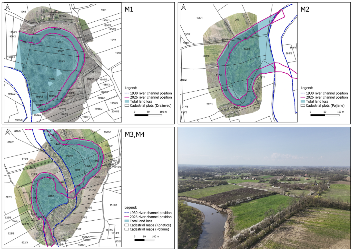
A comprehensive overview of lateral channel migration and riverbank erosion intensity during the period 1930–2026 constitutes the initial component of the analysis. The research results revealed intensive morphodynamics of the Kolubara River across all four observed meanders. During the observed period, the maximum lateral migration (Mmax) reached 259.3 m (2.67 m/year) at Meander 2 (Figure 2). Downstream, Meander 1 exhibited a comparably high maximum migration, totalling at 249.2 m or 2.57 m/year. The two upstream meanders showed somewhat lower, yet still significant displacement values: Meander 3 at 2.20 m/year or 211 m in total, and Meander 4 at 1.99 m/year or 194 m in total (Table 1). These results indicate that the studied sector of the Kolubara River is highly susceptible to severe riverbank erosion.
Figure 2. Change in the position of the Kolubara river channel evidenced in the observed sectors (M1-M4)
| River sector | Lateral channel migration | Land loss | ||
|---|---|---|---|---|
| (Mmax) | (AMmax) | TLL | ALL | |
| Meander 1 | 249.2 | 2.57 | 6.41 | 0.07 |
| Meander 2 | 259.3 | 2.67 | 3.27 | 0.03 |
| Meander 3 | 211.4 | 2.20 | 4.85 | 0.05 |
| Meander 4 | 193.7 | 1.99 | 3.27 | 0.03 |
| Note: M max – maximum lateral channel migration (m); AM max – average annual maximum lateral migration (m/year); TLL – total land loss (ha), ALL – average annual land loss (ha/year); Source: Authors’ calculations | ||||
The intensity of the lateral channel migration serves as a direct indicator of the land loss dynamics. Therefore, further analysis included observation of the total and average annual land loss caused by the riverbank erosion along the defined sectors of the Kolubara River (Table 1). The most significant total land loss was recorded at Meander 1, amounting to 6.41 ha over the 97-year period (1930–2026), with an average annual loss of 0.07 ha/year. Although Meander 2 exhibited the most intense lateral migration, it recorded a comparatively lower land loss of 3.3 ha (0.03 ha/year). For instance, this condition was primarily driven by the position, shape, and local topographic features of this meander, which induced pronounced channel translation rather than areal expansion of the eroded zone. Substantial land degradation was also recorded at Meander 3 (4.8 ha or 0.05 ha/year) and Meander 4 (3.3 ha or 0.03 ha/year). The total land loss within the investigated sectors amounted to 17.6 ha, at an average annual rate of approximately 0.2 ha/year.
3.2 Land-use changes
Regarding administrative divisions, the highest amount of land loss occurred within the cadastral municipality of Poljane (Figure 3). This settlement lost the total of 6.5 ha of land due to the erosion of meanders 2 and 4. This was followed by the cadastral municipality of Draževac with 6.4 ha (Meander 1), while CM Konatice recorded the minimum land loss of 4.8 ha (Meander 4). The total land loss within the investigated sectors of the Kolubara River amounted to approximately 17.6 ha.
Figure 3. Land-use changes along the observed sector of the Kolubara River
Within the cadastral municipality of Draževac (Meander 1), riverbank erosion reduced the arable land from 8.1 ha in 1930 to 1.8 ha in 2026, corresponding to a reduction of approximately 78%. In parallel, newly formed point bars area covered by shrubby vegetation increased by 6.3 ha. In the second cadastral municipality of Poljane, the riverbank erosion was equally intense; out of nearly 16 ha of agricultural land in 1930, only 9.3 ha remained, representing a reduction of approximately 42%. In addition to the loss of agricultural areas, an area of 0.06 ha under local rural roads was permanently lost. At the same time, the area covered by newly formed point bars increased by 6.5 ha. Significant erosion along the concave bank resulted in the loss of around 4.8 ha of agricultural land during the studied period, marking a decline of almost 56.5% on the territory of CM Konatice. Within this municipality, the total surface under point bars also increased by 4.8 ha during the investigated period (Figure 4).
Figure 4. Eroded land areas and degraded plots of land along the investigated sector (M1-M4) of the Kolubara River
These findings demonstrate that the riverbank erosion processes over the past century have accelerated to a critical level. These dynamics triggers a chain of important socio-economic impacts, including reduction of arable land, reduced agricultural production, local infrastructure damage, the disruption of economic activities through land-use changes, etc. Notably, this loss of arable land is practically irreversible. Productive fields on the concave banks are permanently eroded, whereas the newly deposited land on point bars is covered by wild shrubs and woody vegetation, offering no value for agricultural recovery (Yousefi et al., 2018; Langović et al., 2024).
3.3 Economic consequences and demographic changes
Riverbank erosion causes a significant material damage to landowners, the local economy, and rural infrastructure. Previous research (Dragićević et al., 2017b), which focused on broader spatial coverage across the lower Kolubara River Basin (Obrenovac Municipality), revealed that between 1930 and 2010, riverbank erosion caused the total land loss of 67.3 ha, including 39.6 ha of arable land. The total monetary value of that land loss reached 80,560 USD, while the total loss in agricultural production was estimated at 634,240 USD (1982 = 100).
In the present study, which focuses specifically on the four selected meanders and the 1930–2026 period, the total estimated value of land loss amounts to approximately 24,112 USD. The conducted scenario analysis also allows for a variation in land cost, which ranges from the minimal value that was included in the basic scenario to the maximal value, which is 2,734 USD/ha according to the real-estate agency data in the Obrenovac Municipality. Total agricultural production losses were not calculated for the 1930–2026 period due to data limitations, but they likely exceed the direct land value losses many times over.
The population dynamics of Draževac, Konatice, and Poljane reflect the environmental changes caused by the riverbank erosion of the Kolubara River. From 1961 to 2022, all three settlements experienced total population decreases exceeding 40%, indicating a notable spatial consistency in the intensity of the decline. Draževac, the largest settlement with 1,056 inhabitants in 2022, recorded 41.1% population decrease compared to 1961 (1,793 inhabitants). Konatice recorded 45.6% decline (from 1,285 inhabitants in 1961 to 699 in 2022), while the smallest settlement of Poljane, experienced the sharpest decline of 52% (from 652 inhabitants in 1961 to 313 in 2022) (Figure 5). The observed shifts in total population, resulting from both unfavourable natural increase and population mobility trends, have shaped complex structural differences in the demographic profiles of these settlements over time.
Figure 5. Total population of Draževac, Konatice, and Poljane, 1961–2022.
Source: SORS, 2014; SORS, 2023.
In accordance with these changes, a structural transformation in economic activity patterns was identified across all three settlements, mainly indicated by the diminished dominance of the primary sector. In 1961, at the beginning of the observed period, most of the economically active population was employed in the primary sector, specifically in agriculture (Draževac: 90%; Konatice: 92.4%; Poljane: 91.4%). The results from the most recent census in 2022 illustrate that the share of the population employed in this sector decreased radically to 0.5% in Draževac, 2% in Konatice, and 0.9% in Poljane. The engagement of economically active persons in the primary sector in 1961 corresponded to the total population by settlement, while the pronounced decrease recorded in 2022 did not follow this pattern (Table 2).
| Settlement | 1961 | 2022 | ||
|---|---|---|---|---|
| n | % | n | % | |
| Draževac | 748 | 90 | 2 | 0.5 |
| Konatice | 557 | 92.4 | 5 | 2 |
| Poljane | 245 | 91.4 | 1 | 0.9 |
| Source: SORS, 2026 . | ||||
In addition to the extremely low participation of persons employed in the primary sector, the 2022 census recorded no individuals in this sector in the 15–19 age group, and only five persons in total in the 20–59 age group across all three settlements (SORS, 2026). This confirms once again that career opportunities are predominantly pursued in occupations unrelated to the primary sector and that generational differences in this regard are becoming less noticeable. However, the possibility that some residents may be engaged in agriculture, forestry, and fishery as additional activities does not completely eliminate optimistic future projections regarding primary sector revitalization.
These findings align with other evidence indicating that rural areas in Serbia are facing complex population challenges (Živanović et al., 2022; Langović et al., 2026). Although demographic changes in these three settlements have been influenced by other factors, the analysis highlights that agricultural land loss along the Kolubara River is an important contextual element when examining the current economic structure of the population. Local demographic trajectories reflect broader socioeconomic dynamics, population size, and settlement area. For instance, Draževac, the largest settlement both demographically (1,056 inhabitants) and according to the surface area, experienced the highest absolute and relative arable land loss (78%). However, its larger population size provided greater demographic resilience, resulting in a relatively moderate population decline (41.1%). Conversely, Poljane, the smallest and most vulnerable settlement (313 inhabitants), recorded a lower rate of arable land loss (42%) together with a higher population decline (52.0%). This disparity demonstrates that land loss functions as part of a broader set of demographic and economic factors, rather than the primary cause of depopulation.
On an individual level, property owners (mostly private farms) suffered irreversible damage through measured permanent land loss and opportunity costs of agricultural production expressed in lost potential income from crop production in the research territory. The Legal framework for the consequences of the degradation of the Kolubara riverbanks in the Obrenovac Municipality is also important. The current challenges facing the owners of the affected plots of land along the Kolubara River raise several legal and environmental questions:
• What are the legal rights of the landowners whose property has been partially eroded or lost to the river, yet who remain obligated to pay property taxes for the original land surface area?
• What is the legal framework for claiming compensation for the yield losses on eroded plots of land?
• What legal mechanisms exist to address the flood damages resulting from inadequate riverbed management?
• What legal procedures and consequences apply when land undergoes reclassification or a change in land-use category?
In a previous piece of research (Dragićević et al., 2017a, 2017b), it was pointed out that adequate solutions for the rehabilitation of endangered riverbanks were identified, as well as the type of solutions (soft and hard engineering) that can be applied to stop lateral erosion. An integrated Kolubara River Basin management plan, with the proper selection of land use and organization of erosion control works, would bring a balanced runoff regime of the river.
A systematic approach to mitigate the adverse effects of the riverbank erosion in these settlements is imposed as an essential strategy. However, decision makers should also consider that the degree of influence of this process can be selective, with the individuals who own plots of land and other property along the river being particularly vulnerable (Dey & Mandal, 2025). To gain a comprehensive understanding of the wider framework, including population perspectives and attitudes toward this process and its effects at the micro level, future research will focus on qualitative studies.
Although this study offers valuable insights into the examined topic, several limitations should be considered. First, the relationship between the riverbank erosion and demographic changes was analysed using a descriptive comparative approach, without the application of advanced statistical modelling or direct correlation procedures. The primary objective of the research was to provide an initial spatial insight into land loss alongside local demographic trends. Second, the analysis did not quantitatively isolate other major confounding drivers, such as the regional economic pull of nearby urban centres, agricultural mechanization, and overarching national rural depopulation trends. Future research will incorporate quantitative correlation measures across multiple time intervals, while explicitly controlling for broader demographic drivers such as migration, population aging, and general urbanization trends. Third, the spatial scope is restricted to four active meanders and three adjacent settlements, which limits broader statistical generalization. Fourth, data constraints permitted a spatial scenario assessment rather than complex predictive modelling.
4 Conclusion
The paper examines the characteristics of the riverbank erosion in the lower part of the Kolubara River Basin, along with an analysis of socioeconomic and population dynamics in the affected settlements of the Obrenovac Municipality. By analysing historical spatial datasets with modern UAV data, the long-term rates of riverbank erosion over a 97-year period (1930–2026) were quantified. Maximum lateral channel migration reached 259.3 m (2.67 m/year), while the total agricultural land loss amounted to 17.6 ha, which is equivalent to 54.3% of the endangered plots of land registered in 1930. Newly deposited point bars offer no immediate agricultural value, rendering the land loss practically permanent for local farmers, unless long-term institutional recultivation and soil remediation measures are applied.
Beside these changes, the affected settlements have undergone significant demographic shifts. The studied settlements experienced population decline ranging from 41% to 52% between 1961 and 2022, accompanied with a profound change in primary sector employment – from over 90% in 1961 to under 2% in 2022. While these demographic trajectories primarily reflect broader regional dynamics, the erosion-driven loss of productive agricultural land represents an additional localized stressor operating alongside these processes. Considering the riverbank erosion as one of the broader elements that may contribute to socioeconomic changes in this area is therefore justified.
These results have several implications for land and water management, environment protection, development strategies and spatial planning. Obtaining an accurate long-term data on lateral channel migration and land loss was the first step towards such detailed analysis. The establishment of a national strategy for the management of land loss due to riverbank erosion is overdue. Future research should be focused on qualitative studies examining adaptive strategies and community perceptions towards this process. Also, it is necessary to construct scenarios for mitigating the negative consequences. Extending this type of integrated geomorphological-demographic analysis to other riverbank erosion prone areas in Serbia represents a priority for building a comprehensive national evidence base. Ultimately, a comprehensive strategy aligned with sustainable development principles must be established, in accordance with the EU environmental accession frameworks and commitments.
This research was supported by the Science Fund of the Republic of Serbia, Grant no. 7358, Population dynamics under environmental challenges in Serbia – POPENVIROS.
Data availability statement
Data are available in the manuscript.
Coauthor contributions
Slavoljub Dragićević: Conceptualization, Formal Analysis, Investigation, Methodology, Supervision, Validation, Visualization, Writing - Original Draft, Writing - Review & Editing
Marko Langović: Conceptualization, Formal Analysis, Methodology, Visualization, Writing - Original Draft, Writing - Review & Editing
Milan Radović: Investigation, Project Administration
Radislav Tošić: Conceptualization, Formal Analysis, Writing - Review & Editing
Milica Langović: Data Curation, Formal Analysis, Methodology, Writing - Original Draft, Writing - Review & Editing
Novica Lovrić: Formal Analysis, Methodology, Writing - Review & Editing
Stefan Manojlović: Visualization, Writing - Review & Editing
References
- Akay, S. S., Özcan, O., Şanlı, F. B., Görüm, T., Şen, Ömer L., & Bayram, B. (2020). UAV-based evaluation of morphological changes induced by extreme rainfall events in meandering rivers. PLoS One, 15(11), e0241293. https://doi.org/10.1371/journal.pone.0241293
- Alber, A., & Piégay, H. (2017). Characterizing and modelling river channel migration rates at a regional scale: Case study of south-east France. Journal of Environmental Management, 202, 479-493. https://doi.org/10.1016/j.jenvman.2016.10.055
- Bertalan, L., Rodrigo-Comino, J., Surian, N., Šulc Michalková, M., Kovács, Z., Szabó, S., Szabó, G., & Hooke, J. (2019). Detailed assessment of spatial and temporal variations in river channel changes and meander evolution as a preliminary work for effective floodplain management. The example of Sajó River, Hungary. Journal of Environmental Management, 248, 109277. https://doi.org/10.1016/j.jenvman.2019.109277
- Birch, J. W., & Sunderman, M. A. (2003). Estimating price paths for residential real estate. Journal of Real Estate Research, 25(3), 277-300. https://doi.org/10.1080/10835547.2003.12091115
- Blanka, V., & Kiss, T. (2011). Effect of different water stages on bank erosion, case study on River Hernád, Hungary. Carpathian Journal of Earth and Environmental Sciences, 6(2), 101-108.
- Chowdhury, M. E., Islam, M. K., & Chowdhury, M. A. (2026). Spatio-temporal dynamics of Riverbank Erosion and community adaptation along the Karnaphuli River, Bangladesh. Discover Hazards, 2(1), 31. https://doi.org/10.1007/s44475-026-00035-2
- Das, T. K., Haldar, S. K., Sarkar, D., Borderon, M., Kienberger, S., Das Gupta, I., Kundu, S., & Guha-Sapir, D. (2017). Impact of Riverbank Erosion: A Case Study. Australasian Journal of Disaster and Trauma Studies, 21(2), 73-81.
- Dey, S., & Mandal, M. (2025). Understanding Disasters, Vulnerabilities, and the Resilience: Impact of RiverBank Erosion on Riparian Communities. In S. Chakraborty & S. S. Satapathy (Eds.), Gender, Environment, and Human Rights: An Intersectional Exploration (pp. 293-316). IGI Global Scientific Publishing. https://doi.org/10.4018/979-8-3693-6069-9.ch015
- Diaconu, D. C., Koutalakis, P. D., Gkiatas, G. T., Dascalu, G. V., & Zaimes, G. N. (2023). River Sand and Gravel Mining Monitoring Using Remote Sensing and UAVs. Sustainability, 15(3), 1944. https://doi.org/10.3390/su15031944
- Dragićević, S., Carević, I., Kostadinov, S., Novkovic, I., Abolmasov, B., Milojković, B., & Simić, D. (2012). Landslide susceptibility zonation in the Kolubara River Basin (western Serbia) - analysis of input data. Carpathian Journal of Earth and Environmental Sciences, 7(2), 37-47.
- Dragićević, S., Pripužić, M., Živković, N., Novković, I., Kostadinov, S., Langović, M., Milojković, B., & Čvorović, Z. (2017a). Spatial and temporal variability of bank erosion during the period 1930-2016: Case study-Kolubara River Basin (Serbia). Water, 9(10), 748. https://doi.org/10.3390/w9100748
- Dragićević, S., Stojanović, Žaklina, Manić, E., Roksandić, M., Stepić, M., Živković, N., Zlatić, M., & Kostadinov, S. (2017b). Economic consequences of bank erosion in the lower part of the Kolubara River Basin, Serbia. Environmental Engineering and Management Journal, 16(2), 381-390. https://doi.org/10.30638/eemj.2017.038
- Dragićević, S., Tošić, R., Stepić, M., Živković, N., & Novković, I. (2013). Consequences of the River Bank Erosion in the Southern Part of the Pannonian Basin: Case Study – Serbia and the Republic of Srpska. Forum Geografic, XII(1), 5-15. https://doi.org/10.5775/fg.2067-4635.2013.008.i
- Dragićević, S., Živković, N., Novković, I., Petrović, A., Tošić, R., & Milevski, I. (2016). Hydrological and suspended sediment regime in the Kolubara River during the extreme year of 2014. Revista De Geomorfologie, 18(1), 32-46. https://doi.org/10.21094/rg.2016.054
- Dragićević, S., Živković, N., Roksandić, M., Luković, J., & Kostadinov, S. (2015). Recent State, Intensity and Consequences of Degradation of the Riverbanks of Kolubara in the Territory of Obrenovac Municipality. Faculty of Geography, University of Belgrade.
- García-Martínez, B., & Rinaldi, M. (2022). Changes in meander geometry over the last 250 years along the lower Guadalquivir River (southern Spain) in response to hydrological and human factors. Geomorphology, 410, 108284. https://doi.org/10.1016/j.geomorph.2022.108284
- Gkiatas, G. T., Koutalakis, P. D., Kasapidis, I. K., Iakovoglou, V., & Zaimes, G. N. (2022). Monitoring and Quantifying the Fluvio-Geomorphological Changes in a Torrent Channel Using Images from Unmanned Aerial Vehicles. Hydrology, 9(10), 184. https://doi.org/10.3390/hydrology9100184
- Hooke, J. (2023). Morphodynamics of active meandering rivers reviewed in a hierarchy of spatial and temporal scales. Geomorphology, 439, 108825. https://doi.org/10.1016/j.geomorph.2023.108825
- Hooke, J. M., & Yorke, L. (2011). Channel bar dynamics on multi-decadal timescales in an active meandering river. Earth Surface Processes and Landforms, 36(14), 1910-1928. https://doi.org/10.1002/esp.2214
- Kiss, T., Fiala, K., & Sipos, G. (2008). Alterations of channel parameters in response to river regulation works since 1840 on the Lower Tisza River (Hungary). Geomorphology, 98(1-2), 96-110. https://doi.org/10.1016/j.geomorph.2007.02.027
- Kostadinov, S., Dragićević, S., Stefanović, T., Novković, I., & Petrović, A. M. (2017). Torrential flood prevention in the Kolubara river basin. Journal of Mountain Science, 14(11), 2230-2245. https://doi.org/10.1007/s11629-017-4575-9
- Langović, M., Dragićević, S., Novković, I., Živković, N., Tošić, R., Milojković, B., & Čvorović, Z. (2021). Assessment of the soil loss caused by riverbank erosion in Serbia. Bulletin of the Serbian Geographical Society, 101(1), 31-47. https://doi.org/10.2298/gsgd2101031l
- Langović, M., Popović, S., Dragićević, S., Stojanović, Žaklina, & Manić, E. (2024). Assessment of the Economic Consequences of Riverbank Erosion: The Case of the South Morava River, Serbia. Water Economics and Policy, 10(02), 2450003. https://doi.org/10.1142/s2382624x24500036
- Langović, M., Srećković, V. A., & Vidović, Z. (2026). Trend Analysis of Internal Migration in Serbia. Mitteilungen Der Österreichischen Geographischen Gesellschaft, 167, 255-277. https://doi.org/10.1553/moegg167-112
- Lovrić, N., & Tošić, R. (2016). Assessment of Bank Erosion, Accretion and Channel Shifting Using Remote Sensing and GIS: Case Study – Lower Course of the Bosna River. Quaestiones Geographicae, 35(1), 81-92. https://doi.org/10.1515/quageo-2016-0008
- Petrović, A. M., Dragićević, S. S., Radić, B. P., & Milanović Pešić, A. Z. (2015). Historical torrential flood events in the Kolubara river basin. Natural Hazards, 79(1), 537-547. https://doi.org/10.1007/s11069-015-1860-1
- Rahman, M. N., Sharifuzzaman, S. A. S. M., Sarker, M. N. I., & Lo, K. (2025). Socioeconomic impacts and migration dynamics of riverbank erosion. Npj Climate Action, 4(1), 102. https://doi.org/10.1038/s44168-025-00306-6
- Rana, M. F., Ar Rafi, A., Saha, O. R., Haque, A., Deb, S., Sonet, S. S., & Islam, M. R. (2026). Socioeconomic consequences of riverbank erosion and accretion along the Dhaleshwari river in Tangail district of Bangladesh. Discover Geoscience, 4(1), 31. https://doi.org/10.1007/s44288-026-00402-y
- Roksandic, M., Dragicevic, S., Zivkovic, N., Kostadinov, S., Zlatic, M., & Martinovic, M. (2011). Bank erosion as a factor of soil loss and land use changes in the Kolubara river basin, Serbia. African Journal of Agricultural Research, 6(32), 6604-6608. https://doi.org/10.5897/ajar11.736
- Rusnák, M., Opravil, Šimon, Dunesme, S., Afzali, H., Rey, L., Parmentier, H., & Piégay, H. (2025). A channel shifting GIS toolbox for exploring floodplain dynamics through channel erosion and deposition. Geomorphology, 477, 109688. https://doi.org/10.1016/j.geomorph.2025.109688
- Sohan, A. H. S., Hossain, M. I., Sayed, A., Dey, A. S., & Ni, P. (2026). Application of Geo-Bag and Cement Concrete Blocks in Riverbank Erosion Control: A Study of Satkhira Koyra. Sustainability, 18(1), 39. https://doi.org/10.3390/su18010039
- Statistical Office of the Republic of Serbia. (2014). Comparative overview of the number of population in 1948, 1953, 1961, 1971, 1981, 1991, 2002 and 2011: Data by settlements. https://publikacije.stat.gov.rs/G2014/Pdf/G20144008.pdf
- Statistical Office of the Republic of Serbia. (2023). 2022 Census of Population, Households and Dwellings: Age and sex—Data by settlements. https://publikacije.stat.gov.rs/G2023/pdf/G20234003.pdf
- Statistical Office of the Republic of Serbia. (2025). Municipalities and regions of the Republic of Serbia, 2025. https://publikacije.stat.gov.rs/G2025/PdfE/G202513052.pdf
- Statistical Office of the Republic of Serbia. (2026). Economically active population by sectors of activities in 1961 and 2022.
- Tošić, R., Lovrić, N., & Dragićević, S. (2014). Land use changes caused by bank erosion along the lower part of the Bosna River from 2001 to 2013. Bulletin of the Serbian Geographical Society, 94(4), 49-58. https://doi.org/10.2298/gsgd1404049t
- Yousefi, S., Mirzaee, S., Keesstra, S., Surian, N., Pourghasemi, H. R., Zakizadeh, H. R., & Tabibian, S. (2018). Effects of an extreme flood on river morphology (case study: Karoon River, Iran). Geomorphology, 304, 30-39. https://doi.org/10.1016/j.geomorph.2017.12.034
- Živanović, V., Joksimović, M., Golić, R., Malinić, V., Krstić, F., Sedlak, M., & Kovjanić, A. (2022). Depopulated and Abandoned Areas in Serbia in the 21st Century - From a Local to a National Problem. Sustainability, 14(17), 10765. https://doi.org/10.3390/su141710765
Article Details
Published by the Institute of Social Sciences - Center for Demographic Research